Introduction
Use Cases: Agro-Insurance risk assessment, governments, food processing, contract farming
Due to progressing climate change, droughts threaten agricultural systems all over the world more and more often. Food processors, agro-insurances and governments are facing the problem of getting an objective overview of the actual vegetation development at state, regional and local level. In particular droughts are posing a systematic risk to production. Politicians need to know if farmers require help. We have developed the Regional Crop Performance Service based on the VCI (Vegetation Condition Index) which is a proven drought indicator also used by FAO. It is available as application and map services for integration into IT systems. This service allows to effectively monitor drought (and other natural hazard) risks based on the observed crop development down to the village level (and other administrative units such as revenue circles, agroinsurance-units, subdistricts, districts and even federal states or provinces).
This brings significant benefits to you:
- understanding current vegetation condition
- timely updates on the actual drought risk
- enables crop risk assessment and mitigation from continental level down to village level
- available globally and based on a 20-year historical data stack
- adapt and improve irrigation practices
- localization of crop growth anomalies
Description
The VCI is a very robust crop performance indicator during drought, flood and other natural hazard alerts. It is very well known from platforms such as the FAO agricultural vulnerability monitor, the IWMI drought monitoring system, Copernicus Global Land Service, the GEOGLAM Crop Monitor or several regional scale research studies (Zambrano et al., Dutta et al. or Liang et al.). But in contrast to the publicly available products from FAO et al our product is provided in a higher resolution (250 m), integratable in other IT systems and comes with a license allowing its commercial use.
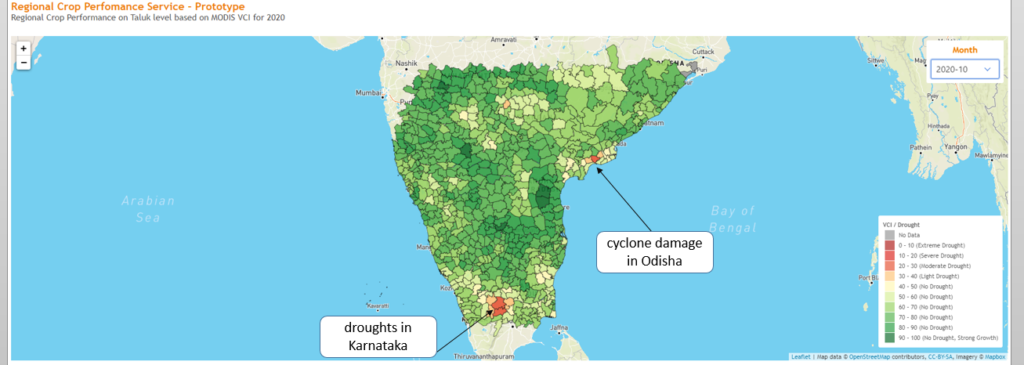
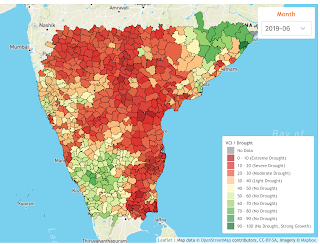
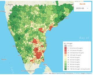
The Regional Crop Performance Service gives a clear indication about the vegetation status in agricultural areas. The drought severeness categorization follows an international recognised classification used by the FAO. It is available for India and it is currently updated on a monthly basis. On request it can also be provided for other regions or with weekly updates.
The product comprises a classified map at Taluk or village level, the time series per regional unit and a detailed map.
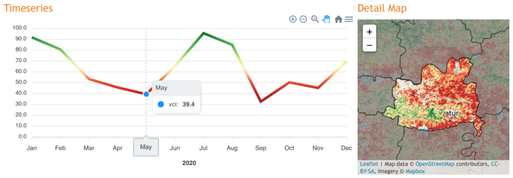
Localization of regional weather anomalies (droughts, cyclones, floods) is possible. A historical analysis of the VCI values for a certain region allows to assess agricultural vulnerability based on regular or re-occurring hazard events. On the other side, the VCI also allows for the assessment of agricultural areas, which are not likely to be exposed to such events. This is crucial for the selection of agriculturally suitable sites for certain crop types and crop varieties.