We offer several tools for free that you can use to visualize and analyze our data. Here they are:
V4 Web clients
We have several DEMO web clients that can be used to register parcels in our system and visualize & analyze their data. Some were designed to showcase the products of a specific agknowledge API package or for a specific use case. They are offered for free and provided to demonstrate the agknowledge API capabilities. They are under continuous development and may change.
V4 Field Agent
The evolution of our Analyst Dashboard, based on our API V4 Products. Giving you the possibility to use state of the art crop monitoring based on satellite data and vegetation indexes. The V4 Field Agent enabels you to display and analyse your field data very easy and clearly arranged, both images and time series.
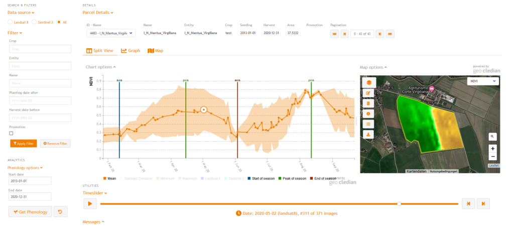
https://geocledian.com/agclient/v4/analyst/?key=YOURKEY
For example to use the V4 Field Agent with the DEMO key go to:https://geocledian.com/agclient/v4/analyst/?key=39553fb7-7f6f-4945-9b84-a4c8745bdbec
V4 Zones Agent
The V4 Zones Agent generates and visualizes our Field Management Zones product in an appealing way. These variable rate application (VRA) maps are essential for precision agriculture or smart farming.
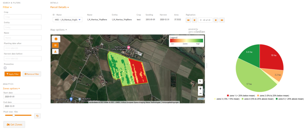
https://geocledian.com/agclient/v4/zones/?key=YOURKEY
For example to use the V4 Zones Agent with the DEMO key go to:https://geocledian.com/agclient/v4/zones/?key=39553fb7-7f6f-4945-9b84-a4c8745bdbec
V4 Harvest Maturity Agent
Based on our well-proven Harvest Maturity product we created a Web client displaying crop growt and the harvest maturity index for individual fields telling you how mature a field is.
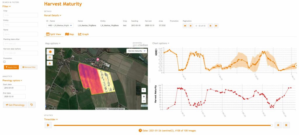
https://geocledian.com/agclient/v4/harvest/?key=YOURKEY
For example use the V4 Harvest Maturity Agent with the DEMO key go to: https://geocledian.com/agclient/v4/harvest/?key=39553fb7-7f6f-4945-9b84-a4c8745bdbec
V4 Data Validation Agent
The Data Validation Agent was designed to give decision makers the possibility to display the results of our Data Validation Products clearly for a large number of parcels.
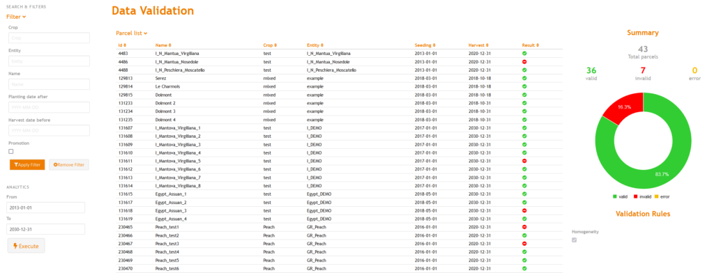
https://geocledian.com/agclient/v4/validation/?key=YOURKEY
For example use the V4 Harvest Maturity Agent with the DEMO key go to: https://geocledian.com/agclient/v4/validation/?key=39553fb7-7f6f-4945-9b84-a4c8745bdbec
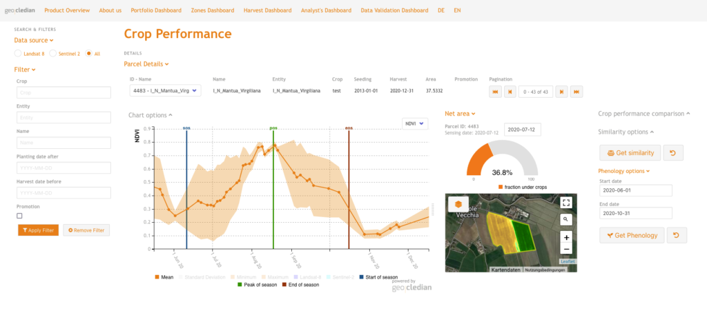
Crop Performance Dashboard
The Crop Performance Dashboard was designed to visualize a field’s crop performance in comparison to surrounding fields of the same crop type. It is based on the agknowledge API products of the Crop Performance package.
https://geocledian.com/agclient/v4/performance/?key=YOURKEY
For example use the V4 Harvest Maturity Agent with the DEMO key go to: https://geocledian.com/agclient/v4/performance/?key=39553fb7-7f6f-4945-9b84-a4c8745bdbec
V3 Web clients
ATTENTION: Our API v3 will not be supported any more after December 31, 2022! Therefore the v3 web clients will also not be supported any more.
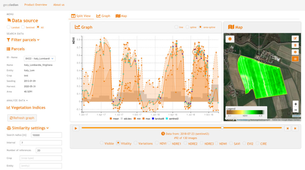
Analyst’s dashboard
The Analyst’s dashboard contains comprehensive data analysis features that enable you to dig deep into your parcel’s data time series. You may use our Analyst’s Dashboard for viewing and analyzing the advanced features of the agknow API here:
https://geocledian.com/agclient/analyst/?key=YOUR_KEY
For example to use the Analyst’s Dashboard with the DEMO key go to:https://geocledian.com/agclient/analyst/?key=39553fb7-7f6f-4945-9b84-a4c8745bdbec
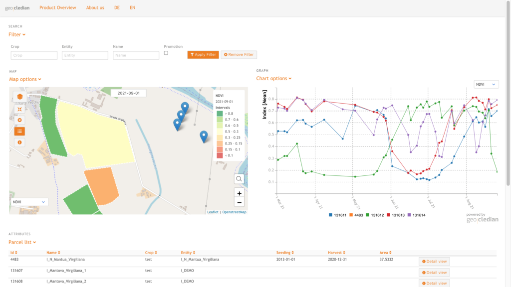
Portfolio Dashboard
Our Portfolio Dashboard is supposed to provide an overview over several parcels close to each other and compare their vegetation development.
Please note, that the Portfolio Dashboard is in beta stage and there are some developments for performance improvements to come. The detail view button is currently revised and therefore deactivated.
https://geocledian.com/agclient/portfolio/?key=YOUR_KEY
For example to use the Portfolio Dashboard with the DEMO key go to:
https://geocledian.com/agclient/portfolio/?key=39553fb7-7f6f-4945-9b84-a4c8745bdbec
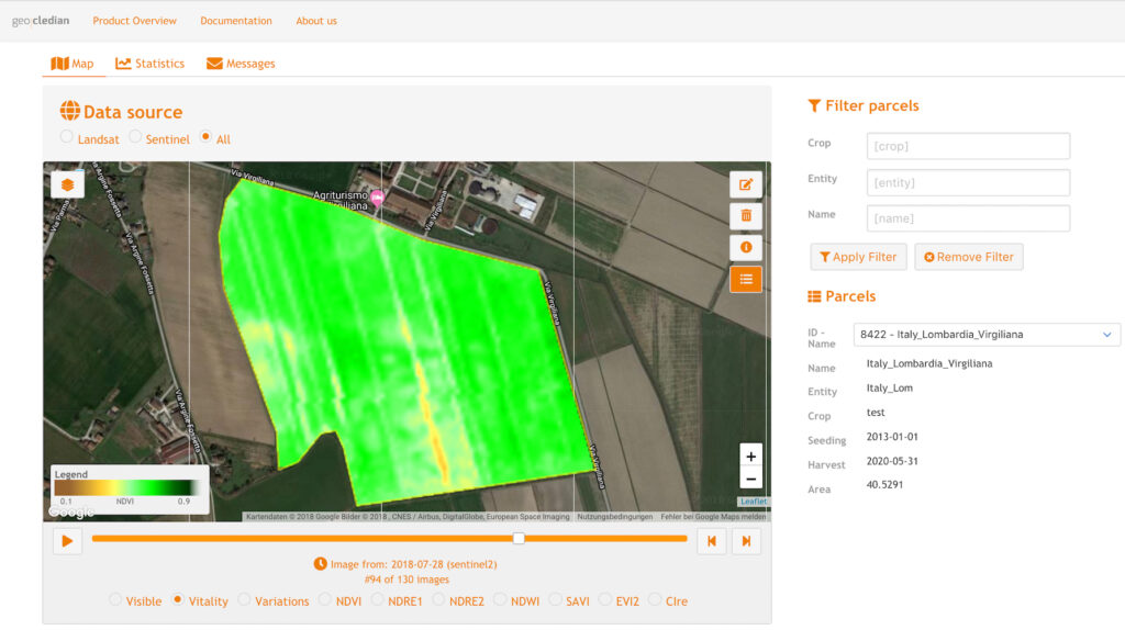
Agknow client
Our simpler Agknow client was designed for users that are not as advanced and simply want to register some parcels and visualize their data. It is also very useful for developers as it shows only the basics how to work with our API and a Javascript client. It’s also useful for checking the parcel messages in a GUI.
You can find it here:
https://geocledian.com/agclient/v2/?key=YOUR_KEY
For example to use the Agknow client with the DEMO key go to:https://geocledian.com/agclient/v2/?key=39553fb7-7f6f-4945-9b84-a4c8745bdbec
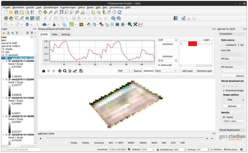
QGIS Plugin
The agknow for QGIS plugin uses the ag|knowledge API from Geocledian. The API provides a field monitoring service that allows to monitor any agricultural field worldwide with a variety of vegetation indexes, crop parameters, times series analysis and comparison features based on satellite data. Features of the plugin include the download and analysis of time series of visible and vegetation indexes rasters of registered fields. The data is based on Sentinel-2 currently.
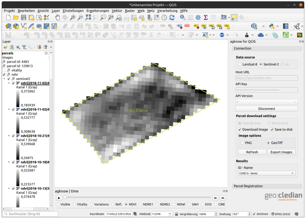
The plugin currently contains these satellite image products from our Basic and Professional Monitoring packages:
- Visible (true colour RGB image)
- Vitality (absolute NDVI image, colour scale optimized for visualization (stretched between 0 – 1))
- Variations (relative NDVI image, colour scale optimized for visualization (stretched between Min – Max))
- Reflection (all Sentinel 2 spectral bands Geotiff, stacked and raw)
- NDVI (Geotiff)
- NDRE1 (Geotiff)
- NDRE2 (Geotiff)
- NDWI (Geotiff)
- SAVI (Geotiff)
- EVI2 (Geotiff)
- CIRE (Geotiff)
Use Cases
Using our agknow for QGIS plugin enables you to directly download, view, edit or integrate our data in your QGIS project for further processing. Beyond that it makes the registering of new parcels in our API very easy.
- Convenient tool for Analysts if they want to work with the data of the agknow API directly in a desktop GIS especially for GeoTiff reflectances and indices
- Export parcel data
- Viewer for GeoTiff output of the API
For further information please see: https://github.com/geocledian/agknow_qgis3
Please go here for our other Open Source components like the widgets.