Overview
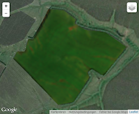
The API is implemented as simple REST service supporting a number of resources.
The documentation is constantly updated to reflect the most current status of the API. Updates are also posted on the NEWS page of this site.
Please don’t hesitate to contact us if you have any questions!
Changelog
2019-03-26: Changes between ag|knowledge API v3.1 and v3.2:
- added parcel promotion parameter
- &promition=true
- JSON response object:
General remarks
- The reference coordinate system of all parcel geometries is WGS84/EPSG:4326. The raster-images are projected in EPSG:3857 for web mapping applications.
- All characters in text fields should be UTF-8.
- All dates are in this format: YYYY-MM-DD.
- We are using the open standard formats GeoJSON and WKT to represent and exchange data of geographical features such as points and polygons.
- ATTENTION: In both formats the coordinate order is: longitude, latitude, so x, y. The most common issue when working with geographical data is a flip of coordinates. If something is not working, always first check if the coordinates are passed correctly between the different systems. This is especially true, when working with javascript mapping libraries (e.g leaflet.js, mapbox.js, Google Map API), where the LatLon base class uses the reverse coordinate order: latitude, longitude.
- EXCEPTION: There is one exception where we don’t use GeoJSON or WKT for the exchange of geographical data: in the raster product response there is a „bounds“ element, which is an object that can be used directly as input in a Leaflet or Mapbox javascript application. Therefore its coordinate order is latitude, longitude.
- Whenever you send our API geometries we expect valid parcel geometries according to OGC simple feature specification. We try to make all invalid geometries that we receive valid, e.g. intersecting polygons are splitted into a multipolygon geometry.
- We reduce parcel geometries to 12 decimal digits and expect them to be valid after that.
- The minimum parcel size is 0.04 ha, the maximum size 4000 ha. Landsat-8 data is only delivered for parcels larger than 0.4 ha. Below that it doesn’t make sense from a technical point of view.
- All raster ids can change from time to time. Please make sure your system can cope with that. This is necessary e.g. because we regularly reprocess data to improve data quality and keep track of changing satellite product formats. You can use our Notification Messages to keep track of changes.
Base URL
URL: „https://geocledian.com/agknow/api/v3“ (or „https://geocledian.com/agknow/“)
Available Resources
<base URL> | version information of API |
/parcels | access to a list of parcel objects |
/parcels/<id> | access to parcels object with <id> |
/parcels/<id>/<product_name> | access to rasters product for this parcel |
/parcels/<id>/<product_name>/<id> (/parcels/<product_name>/<id>) | access to rasters product object with <id> from default source |
/parcels/<id>/<product_name>/<source_name>/<id> | access to rasters product object with <id> and <source_name> |
/parcels/<id>/vitality?key=<YOUR_KEY>&statistics=true | time series of NDVI summary statistics for this parcel |
/parcels/<product_name> | access to rasters product layer |
/parcels/<id>/messages | access to notification messages for this parcel |
/messages | access to list of messages for all parcels |
Parcels
Resource URL: /parcels
List
Function helps to search for parcels stored in the DB
HTTP Request:
GET https://geocledian.com/agknow/api/v3/parcels?key=kkk&entity=eee&name=nnn&crop=ccc&promotion=ttt
Required parameters
key | registered user key to authorize user default: none |
Optional parameters
entity | farm name or other type of unit, used to filter the result default: any entity |
name | name of parcel, used to filter the result. can be full name or substring default; any name |
crop | crop type, free text to be searched default: any crop |
limit | limit the number of records in the list default: 1000 |
offset | skip the first n records default: 0 |
promotion | filter for promotional parcels. valid values: „true“ or „false“ default: false |
GET
https://geocledian.com/agknow/api/v3/parcels?key=39553fb7-7f6f-4945-9b84-a4c8745bdbec
Response
{
"content":[
{
"parcel_id":3243,
"crop":"winter weat",
"entity":"Smith",
"name":"Lipatse-1",
"promotion":false,
"centroid":{
"type":"Point",
"coordinates":[
24.4621182,
58.667103
]
}
},
{
"parcel_id":2,
"crop":"winter weat",
"entity":"Smith",
"name":"Lipatse-2",
"promotion":false,
"centroid":{
"type":"Point",
"coordinates":[
24.5621182,
58.767103
]
}
},
{
"..."
}
]
}
Get
Function delivers basic information about one parcel
HTTP Request:
GET https://geocledian.com/agknow/api/v3/parcels/<id>?key=kkk&geoformat=<GEOJSON/WKT>
Path Parameters
id | id of parcel |
Required parameters
key | registered user key to authorize user default: none |
Optional parameters
geoformat | valid values: „GeoJSON“ or „WKT“. default: „GeoJSON“ |
Response description
{
"content": [
{
"parcel_id": 1,
"crop": "winter weat",
"entity": null,
"name": "Lipatse-1",
"planting": "2013-10-03"
"harvest": "2014-06-25",
"startdate": "2013-09-03"
"enddate": "2014-07-25",
"area": 35.1392,
"promotion": false,
"geometry": {
"type": "MultiPolygon",
"coordinates": [[[
[ 24.4644524821574, 58.6627809866013 ],
[ 24.4669370269166, 58.6645081129504],
...
[ 24.4542649499116, 58.6688332110932 ],
[ 24.4644524821574, 58.6627809866013 ],
]]]
},
"centroid": {"type": "Point",
"coordinates": [24.5621182,58.767103]
},
"lastupdate":"not implemented yet"
}
]
}
Create
Function registers a new parcel in the database. Make sure that you set the „Content-Type“ header to „application/json„.
HTTP Request:
POST https://geocledian.com/agknow/api/v3/parcels
Input:
{
"key":{
"string"
},
"geometry":{
"string"
},
"crop":{
"string"
},
"planting":{
"string"
},
"harvest":{
"string"
},
"name":{
"string"
},
"entity":{
"string"
},
"promotion":{
"Boolean"
}
}
Path Parameters
Required properties
key | registered user key to authorize user default: none |
geometry | geometry as a polygon (after OGC simple feature specification) in GeoJSON or WKT format. Area min. 0.04 ha, max. 4000 ha. Please note: Landsat-8 data is only delivered for parcels larger than 0.4 ha. |
crop | crop planted, free text (char30) |
planting | planned date of planting in ANSI format: YYYY-MM-DD, e.g. 2015-03-20. Monitoring will start 4 weeks prior this date |
harvest | planned date of harvest in ANSI format: YYYY-MM-DD. Monitoring ends 6 weeks after this date |
Optional properties
entity | farm name or other type of unit, used to filter the result default: any entity (char50) |
name | name of parcel, used to filter the result. can be full name or substring default; any name (char50) |
promotion | flag parcel as promotional parcel valid values: „true“ or „false“ default: false |
Response
{
"errors":{
"string"
},
"messages: {
string: {string}
}
""id""\": {number}
}"
Example
POST https://geocledian.com/agknow/api/v3/parcels
Input
{
"key":"39553fb7-7f6f-4945-9b84-a4c8745bdbec",
"geometry":"POLYGON((24.3635022826436 58.6348436079703,24.3706362398057
58.6352776105966,24.3717480253375 58.6317572115333,24.3649846633526
58.6311302539311,24.3635022826436 58.6348436079703))",
"crop":"winter weat",
"planting":"2015-02-02",
"harvest":"2015-11-01",
"name":"Behind the hedges",
"entity":"Smith",
"promotion":true
}
Response
{
"errors":{
},
"messages: {
""status"": ""successfully created parcel""
}
"id": 93
}"
Delete
Function deletes an existing parcel from the database
HTTP Request:
DELETE https://geocledian.com/agknow/api/v3/parcels/<id>?key=xxx
Path Parameters
id | id of parcel |
Required parameters
key | registered user key to authorize user default: none |
Response
0 = false - nothing deleted
1 = deletion successful
Example
DELETE https://geocledian.com/agknow/api/v3/parcels/111?key=39553fb7-7f6f-4945-9b84-a4c8745bdbec
Response: 1
Summary
This function shows the summary of the number and area of all registered and deleted parcels per key as well as the respective user limits. The start date of the billing period is also displayed. The user can define the registration period for which all parcels should be taken into account.
HTTP Request:
GET https://geocledian.com/agknow/api/v3/parcels?key=kkk&summary=true
Path Parameters
– | – |
Required parameters
key | registered user key to authorize user default: none |
Optional parameters
regstartdate | start date of the registration period that defines which parcels should be considered in format: YYYYMMDD, e.g. 20210101. default = „19000101“ |
regenddate | end date of the registration period that defines which parcels should be considered in format: YYYYMMDD, e.g. 20211231. default = „29000101“ |
All parcels that were registered in this period will be taken into account by the function. If these parameters are omitted all parcels on that key will be taken into account.
Example
GET
https://geocledian.com/agknow/api/v3/parcels?key=39553fb7-7f6f-4945-9b84-a4c8745bdbec&summary=true®startdate=20210101®enddate=20211231
Response
{
"parcel_summary":"productive":{
"count":31,
"area":171.961902950014
},
"deleted_promotion":{
"count":0,
"area":null
},
"deleted_productive":{
"count":1,
"area":1.44271040739
},
"promotion":{
"count":12,
"area":80.9314650491297
},
"active_promotion":{
"count":12,
"area":80.9314650491297
},
"active_productive":{
"count":30,
"area":170.519192542624
}
},
"limits":{
"key_billing_startdate":"2020-01-20",
"promotion":{
"area":83
},
"productive":{
"count":32,
"count_per_day":5,
"area_per_day":8,
"area":190
},
"key_validity_enddate":"2021-07-18",
"key_validity_startdate":"2016-01-01"
}
}
Response parameters
productive | = „active_productive“ + „deleted_productive“ All Non-promotion parcels registered in the defined registration period. |
active_productive | All Non-promotion parcels registered in the defined registration period that are still active. |
deleted_productive | All Non-promotion parcels registered in the defined registration period that were deleted afterwards. |
promotion | = „active_promotion“ + „deleted_promotion“ All promotion parcels registered in the defined registration period. |
active_promotion | All promotion parcels registered in the defined registration period that are still active. |
deleted_promotion | All promotion parcels registered in the defined registration period that were deleted afterwards. |
key_billing_startdate | The date at which the contractual billing period starts. |
promotion | The promotion area limit. Default: 0 ha. (Only available in certain contracts) |
productive | The productive count and area limits. |
key_validity_startdate | The key activation date. |
key_validity_enddate | The key expiration date. |
Rasters products
Resource associated to parcelsResource URL: /parcels/<id>/<product_name>
List
Function lists all available rasters for that product for the parcel. A summary element is given if &statistics=true is set. In this case additional key elements, such as „doy“ for day of year are added to the response list.
ATTENTION: in the raster product response there is a „bounds“ element, which is an object that can be used directly as input in a Leaflet or Mapbox javascript application. Unlike in GeoJSON or WKT representations of geographical features its coordinate order is latitude, longitude.
HTTP Request:
GET https://geocledian.com/agknow/api/v3/parcels/<parcel-id>/<product_name>?key=kkk&statistics=sss&start_date=ddd&end_date=eee&deltadays=ttt&order=~date
Path Parameters
parcel-id | id of parcel |
product_name | Rasters product. valid values: „visible“, vitality“ and „variations“ |
Required parameters:
key | registered user key to authorize user default: none |
Optional parameters
statistics | Add the statistics object to the rasters objects. Valid value: „true“ (only works with the vitaltiy product) default: none |
source | Filter the list by soure, else a comined list of products derived from Sentinel-2 and Landsat-8 will be returned. Valid values: „sentinel2“, „landsat8“ default: none |
start_date | start date in ANSI format: YYYY-MM-DD, e.g. 2015-03-20. default = „1900-01-01“ |
end_date | end date in ANSI format: YYYY-MM-DD, e.g. 2015-10-20. default = „2900-01-01“ |
delta_days | Offset days after start_date, which should appear in the raster product list. If the end_date parameter is given too, then the one which is closer to start_date will be applied. default = 999999 |
order | sort order of the list. e.g. latest date first possible values: „date“, „~date“ default „~date“ for latest date to first date descending |
lon | longitude coordinate, add a pixel value of the NDVI at the requested location to the response list (element name: „pixel_value“). valid values: [-180.0, 180.0] Requires a valid lat parameter too and only works with the product types „variations“ and „vitality“. default: none |
lat | latitude coordinate, add a pixel value of the NDVI at the requested location to the response list (element name: „pixel_value“). valid values: [-75.0, 75.0] Requires a valid lon parameter too and only works with the product types „variations“ and „vitality“. default: none |
Example:
GET
https://geocledian.com/agknow/api/v3/parcels/4483/vitality?key=39553fb7-7f6f-4945-9b84-a4c8745bdbec
{
"content":[
{
"parcel_id":3243,
"bounds":[
[
45.1183299034536,
10.8280456066132
],
[
45.1247009515298,
10.8384781978379
]
],
"raster_id":161504,
"date":"2015-10-12",
"product":"vitality",
"source":"landsat8",
"png":"/parcels/3243/vitality/161504.png"
},
{
"... next object"
}
]
}
Get
Function returns metadata for a single raster product.
ATTENTION: in the raster product response there is a „bounds“ element, which is an object that can be used directly as input in a Leaflet or Mapbox javascript application. Unlike in GeoJSON or WKT representations of geographical features its coordinate order is latitude, longitude.
HTTP Request:
GET https://geocledian.com/agknow/api/v3/parcels/<parcel-id>/<product_name>/<source_name>/<raster-id>&key=kkk&statistics=sss
Path parameters
parcel-id | id of parcel |
product_name | Rasters product. valid values: „visible“, vitality“ and „variations“ |
source_name | Source of the raster product. Valid values: „sentinel2“, „landsat8“. „landsat8“ is assumed as source if no <source_name> is present in the path. |
raster-id | id of raster. The raster-id is unique only for one product, e.g. „visible“. The rasters for different products, e.g. „visible“ and „vitality“, have the same id. |
Required parameters
key | registered user key to authorize user default: none |
Optional parameters
statistics | Add the statistics object to the rasters objects. Valid value: „true“ (only works with the vitaltiy product) default: none |
lon | longitude coordinate, add a pixel value of the NDVI at the requested location to the response content (element names: „pixel_value“ and „lon_lat“). valid values: [-180.0, 180.0] Requires a valid lat parameter too and only works with the product types „variations“ and „vitality“. default: none |
lat | latitude coordinate, add a pixel value of the NDVI at the requested location to the response content (element names: „pixel_value“ and „lon_lat“). valid values: [-75.0, 75.0] Requires a valid lon parameter too and only works with the product types „variations“ and „vitality“. default: none |
Example
GET https://geocledian.com/agknow/api/v3/parcels/4483/vitality/sentinel2/4373343?key=39553fb7-7f6f-4945-9b84-a4c8745bdbec
{
"content":[
{
"parcel_id":3243,
"bounds":[
[
45.1183299034536,
10.8280456066132
],
[
45.1247009515298,
10.8384781978379
]
],
"raster_id":161504,
"date":"2015-10-12",
"product":"vitality",
"source":"landsat8",
"png":"/parcels/3243/vitality/landsat8/161504.png"
}
]
}
Raster
Function returns png or geotiff raster product file.
The raster-images are projected in EPSG:3857 for web mapping applications. The resolution is 5m for Sentinel-2 and 10m for Landsat-8.
HTTP Request:
GET https://geocledian.com/agknow/api/v3/parcels/<parcel-id>/<product_name>/<source_name>/<raster-id>.<format>
Path parameters
parcel-id | id of parcel |
product_name | Rasters product. valid values: „visible“, vitality“ and „variations“ |
source_name | Source of the raster product. Valid values: „sentinel2“, „landsat8“. „landsat8“ is assumed as source if no <source_name> is present in the path. |
raster-id | id of raster. The raster-id is unique only for one product, e.g. „visible“. The rasters for different products, e.g. „visible“ and „vitality“, have the same id. |
format | desired format, currently .png and .tif are supported (geotiff only for vitality) |
Required parameters
key | registered user key to authorize user default: none |
Optional parameters
legend | Instead of the parcel image a colormap is shown which can be used as a legend. Valid value: „true“ (works with the vitaltiy and variations product) default: none |
Responsepng or geotiff file
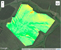
Example of a raster image for the vitality product
GET https://geocledian.com/agknow/api/v3/parcels/4483/vitality/sentinel2/4373343.png?key=39553fb7-7f6f-4945-9b84-a4c8745bdbec
Example of vitality colormap
GET https://geocledian.com/agknow/api/v3/parcels/4483/vitality/sentinel2/4373343.png?key=39553fb7-7f6f-4945-9b84-a4c8745bdbec&legend=true
0.1 vitality (NDVI) 0.9
In the vitality colormap the brown value means no living green vegetation (NDVI value <= 0.1) and dark green means dense living green vegetation (NDVI value >= 0.9).
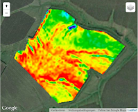
Example of a raster image for the variations product
GET https://geocledian.com/agknow/api/v3/parcels/4483/variations/sentinel2/4373343.png?key=39553fb7-7f6f-4945-9b84-a4c8745bdbec
Example of variations colormap
GET https://geocledian.com/agknow/api/v3/parcels/4483/variations/sentinel2/4373343.png?key=39553fb7-7f6f-4945-9b84-a4c8745bdbec&legend=true
<min> variations (NDVI) <max>
In the variations colormap the dark blue value stands for the minimum NDVI value in the parcel (see next section how to obtain the statistics values as JSON objects) and dark red indicates the maximum NDVI values within the parcel for the measurement date.
NDVI Statistics
Resource associated to parcelsResource URL: /parcels/<id>/vitality?statistics=true
List
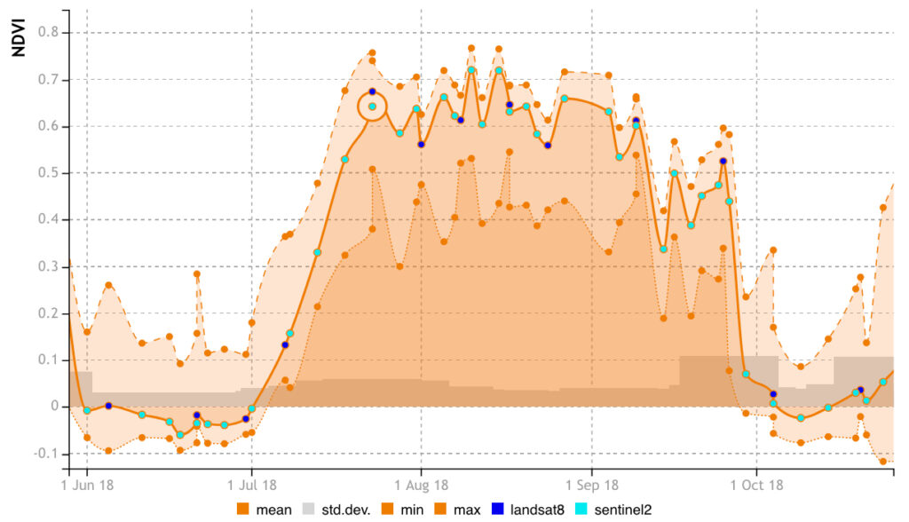
Function delivers time series information about the NDVI development of the parcel. It is the same URL as the raster list for the vitality product, but requires the &statistics=true parameter at the end.
HTTP Request:
GET https://geocledian.com/agknow/api/v3/parcels/<parcel-id>/vitality?key=kkk&statistics=true
Path Parameters
parcel-id | id of parcel |
product_name | Rasters product. Valid values: „vitality“ |
Required parameters:
key | registered user key to authorize user default: none |
statistics | Add the statistics object to the rasters objects. Valid value: „true“ default: none |
Example:
GET https://geocledian.com/agknow/api/v3/parcels/4483/vitality?key=39553fb7-7f6f-4945-9b84-a4c8745bdbec&statistics=true
{
"content":[
{
"parcel_id":3243,
"bounds":[
[
45.1183299034536,
10.8280456066132
],
[
45.1247009515298,
10.8384781978379
]
],
"raster_id":161504,
"date":"2015-10-12",
"product":"vitality",
"source":"landsat8",
"png":"/parcels/3243/vitality/161504.png",
"statistics":{
"count":7545,
"min":-0.0270926225930452,
"max":0.400043338537216,
"sum":688.139426073849,
"stddev":0.0718575498030961,
"mean":0.0912046953046851
}
},
{
"... next object"
}
]
}
Rasters product Layer
Resource associated to parcels
Resource URL: /parcels/<product_name>?format=<format>&date=<date>
List
Function lists all available rasters products with corresponding format/date
HTTP Request:
GET https://geocledian.com/agknow/api/v3/parcels/<product_name>?key=kkk&date=<all/latest>
Required parameters:
key | registered user key to authorize user default: none |
product_name | Rasters product. valid values: „visible“, vitality“ and „variations“. |
Optional parameters
date | closest date of the output rasters. valid values: „latest“, „YYYY-MM-DD“. Default: „latest“ |
entity | farm name or other type of unit, used to filter the result default: any entity |
name | name of parcel, used to filter the result. can be full name or substring default; any name |
crop | crop type, free text to be searched default: any crop |
Example:GET
https://geocledian.com/agknow/api/v3/parcels/vitality?key=39553fb7-7f6f-4945-9b84-a4c8745bdbec
Response:
{
"content":[
{
"parcel_id":3243,
"raster_id":161504,
"bounds":[
[
58.6627794294375,
24.4541126499177
],
[
58.6704532327539,
24.4679793471385
]
],
"crop":"rice",
"entity":"customer-x",
"centroid":{
"type":"Point",
"coordinates":[
24.5621182,
58.767103
]
},
"name":"Lipatse-1",
"procuct":"vitality",
"source":"landsat8",
"png":"/parcels/3243/rasters/161504.png"
},
{
"... next raster"
}
]
}
Notification Messages
Resource URL: /messages
List
Function helps to search all messages for all parcels related to a key.
The messages provide information about the status of each parcel.
These are the available messages:
- „ParcelCreate“: a new parcel has been created, new parcel_id delivered to user. The message has this „message_content“: {„geometry“: „Parcel geometry currently outside of monitoring regions“} if the parcel was created outside a valid monitoring area. In this case no satellite data will available.
- „ParcelProcessing“: Processing the data for the new parcel has started (in rare cases this may happen more than once)
- „ParcelProcessed“: The processing of the new parcel is finished, all available data for this parcel is available
- „ParcelDataUpdate“: there is new satellite data available for a parcel -> a new raster_id has been added (including new products/images) (this happens during the initial parcel processing, every time a historic satellite image has been processed for this new parcel. But also later, every time a parcel is updated with new data)
- „ProductUpdate“: data has been updated for this parcel (e.g. because we reprocessed data). In this case the raster ids change for the products of a certain date
- „ParcelDataDelete“: data has been deleted for this parcel
Note
The „ParcelDataUpdate“ messages are very useful for regular tasks to download all rasters that have been created e.g. in the last 24h. More specific they can be used to:
- follow the parcel processing process while it is still running
- start downloading the first images for a parcel that is currently being processing while processing is still ongoing
- Download all new rasters for all parcels directly from the messages list (without the need to query the raster lists of specific parcels). This is very efficient if you regularly want to check for & download all new rasters that have been processed for all your parcels.
The ParcelDataUpdate message contains the parcel id, the raster id, the satellite source and the image date. This information can be used to directly construct the download link to the corresponding raster: …/parcels/“parcel_id“/vitality/“source“/“raster_id“.png.
HTTP Request:
GET https://geocledian.com/agknow/api/v3/messages?key=kkk&message_severity=mmm&message_code=ccc&message_date_gt=ddd
Path Parameters
Required parameters
key | registered user key to authorize user default: none |
Optional parameters
message_priority | search for priority of the message. valid values: „information“, „warning“, „alert“ default: any value |
message_code | search for a message code. valid values: „ParcelCreate“, „ParcelDataUpdate“, „ParcelDataDelete“, „ProductUpdate“, „ParcelProcessed“, „ParcelProcessing“ default; any message code |
message_date_gt | search for messages after the given date. valid values: „YYYY-MM-DD“ default: „1900-01-01“ |
limit | limit the number of records in the list default: 2000, max: 6000 |
offset | skip the first n records default: 0 |
Response description:
{
"content": [
{
"id": {Number},
"message_code": {String},
"message_description": {String}
"message_date": {String},
"message_priority": {String},
"message_content": {Object},
"parcel_id": {Number} }, { ...next message ...
}
], "count": {Number}, "limit": {Number}, "offset": {Number}
}
Example
GET
https://geocledian.com/agknow/api/v3/messages?key=39553fb7-7f6f-4945-9b84-a4c8745bdbec
Response:
{
"content": [
{
"message_priority": "information",
"message_date": "2016-07-18 11:10:37+02",
"parcel_id": 494,
"message_content": { },
"message_code": "ParcelCreate",
"message_description": "a new parcel has been created, new parcel_id delivered to user",
"id": 1
},
{
"message_priority": "information",
"message_date": "2016-07-18 11:10:38+02",
"parcel_id": 495,
"message_content": { },
"message_code": "ParcelCreate",
"message_description": "a new parcel has been created, new parcel_id delivered to user",
"id": 2
}, {
"message_priority": "information",
"message_date": "2016-07-18 11:10:43+02",
"parcel_id": 494,
"message_content": { },
"message_code": "ParcelProcessing",
"message_description": "Processing the data for the new parcel",
"id": 3
},
{
"message_priority": "information",
"message_date": "2016-07-18 11:10:43+02",
"parcel_id": 494,
"message_content": {
"nb_of_rasters": 2
},
{
"message_code": "ParcelProcessed",
"message_description": "The new parcel has been processed, new rasters for this parcel available",
"id": 4
}
], "count": 5, "limit": 2000, "offset": 0
}
Parcel Notification Messages List
Resource URL: /parcels/<id>/messages
List of messages for the given parcel. These are the same messages as the ones given above.
HTTP Request:
GET https://geocledian.com/agknow/api/v3/parcels/<parcel_id>/messages?key=kkk
Required parameters
key | registered user key to authorize user default: none |
Response description:
{
"content": [
{
"id": {Number},
"message_code": {String},
"message_description": {String}
"message_date": {String},
"message_priority": {String},
"message_content": {Object},
"parcel_id": {Number} },
{ ...next message ...
}
]
}
Example
GET
https://geocledian.com/agknow/api/v3/parcels/4483/messages?key=39553fb7-7f6f-4945-9b84-a4c8745bdbec
Response:
{
"content": [
{
"message_priority": "information",
"message_date": "2016-07-18 11:10:37+02",
"parcel_id": 494,
"message_content": { },
"message_code": "ParcelCreate",
"message_description": "a new parcel has been created, new parcel_id delivered to user",
"id": 1
},
{
"message_priority": "information",
"message_date": "2016-07-18 11:10:43+02",
"parcel_id": 494,
"message_content": { },
"message_code": "ParcelProcessing",
"message_description": "Processing the data for the new parcel",
"id": 3
},
{
"message_priority": "information",
"message_date": "2016-07-18 11:10:43+02",
"parcel_id": 494,
"message_content": {
"nb_of_rasters": 2
},
"message_code": "ParcelProcessed",
"message_description": "The new parcel has been processed, new rasters for this parcel available",
"id": 4
}
]
}